More than a decade has passed since the start of the European Space Agency’s (ESA) Sentinel 4 projects. During that time, our teams have contributed to several projects within the Sentinel 4 mission, including the Sentinel 4 Level 1 Reference Processor, an on-ground satellite data processor. In this blog, I share my experience with Sentinel 4 and offer a closer look at on-ground data processing.
At Gofore, one of our key specialities in the Space domain is developing the on-ground satellite data processors for various Earth Observation missions. I remember on my first day on the S4 mission thinking, “what on Earth is on-ground satellite data processing – it doesn’t sound particularly interesting.”
It didn’t take long before I realized just how critical on-ground processors are to such missions and, while the work is very important, it is also interesting and deeply rewarding.
The Copernicus Sentinel 4 mission
Before diving into the details of what on-ground data processing is, one must first understand a bit more about the mission and the instrument.
The Sentinel 4 instrument is part of the Copernicus Earth Observation program which aims to provide free, open-access EO data used for monitoring Earth’s environment, climate, and security. S4 is one of the six Sentinel missions that are part of the Copernicus Program. Once operational, it will provide high-frequency data of temperature, humidity, and trace gases throughout the atmosphere, specifically over Europe and Northern Africa. S4 was launch as part of MTG-S1 on 1st of July 2025 and is currently undergoing commissioning activities.
The S4 instrument contains 2 Charged Coupled Devices (CCDs), one in the UV-VIS wavelength range and the other in the Near-IR. The instrument scans over Europe and Northern Africa every hour during the daytime and takes images about every second. These images taken on board are called RAW or Level 0 images, which are then downlinked to ground stations on Earth for further processing.
On-ground satellite data processing
The Level 0 data downlinked to Earth includes the raw images captured by the instrument in binary units. As this data is not practical for scientific use in its original form, on-ground processing software converts it into Level 1 data, a format that scientists can use.
The Sentinel 4 Level 1 Reference Processor, which our team has developed, is one of the software systems responsible for this conversion.
However, unit conversion is only a small part of the process. Most of the work consists of correction algorithms that compensate for the instrument’s impurities, imperfections, and physical constraints. For example, the instrument and electronics introduce a small additional signal called dark current, which must be removed. Individual CCD pixels may also respond slightly differently to light, a phenomenon known as pixel response non-uniformity, which also needs to be corrected. After these corrections, the final Level 1 image reflects only the signal captured from Earth.
Nearly a decade of development
With over 70 algorithms and a separate calibration processor, the S4 L1RP has required years of dedicated development. Since the beginning of 2019, a team of 3–10 people have been steadily developing the processor and continue to support the satellite’s commissioning today.
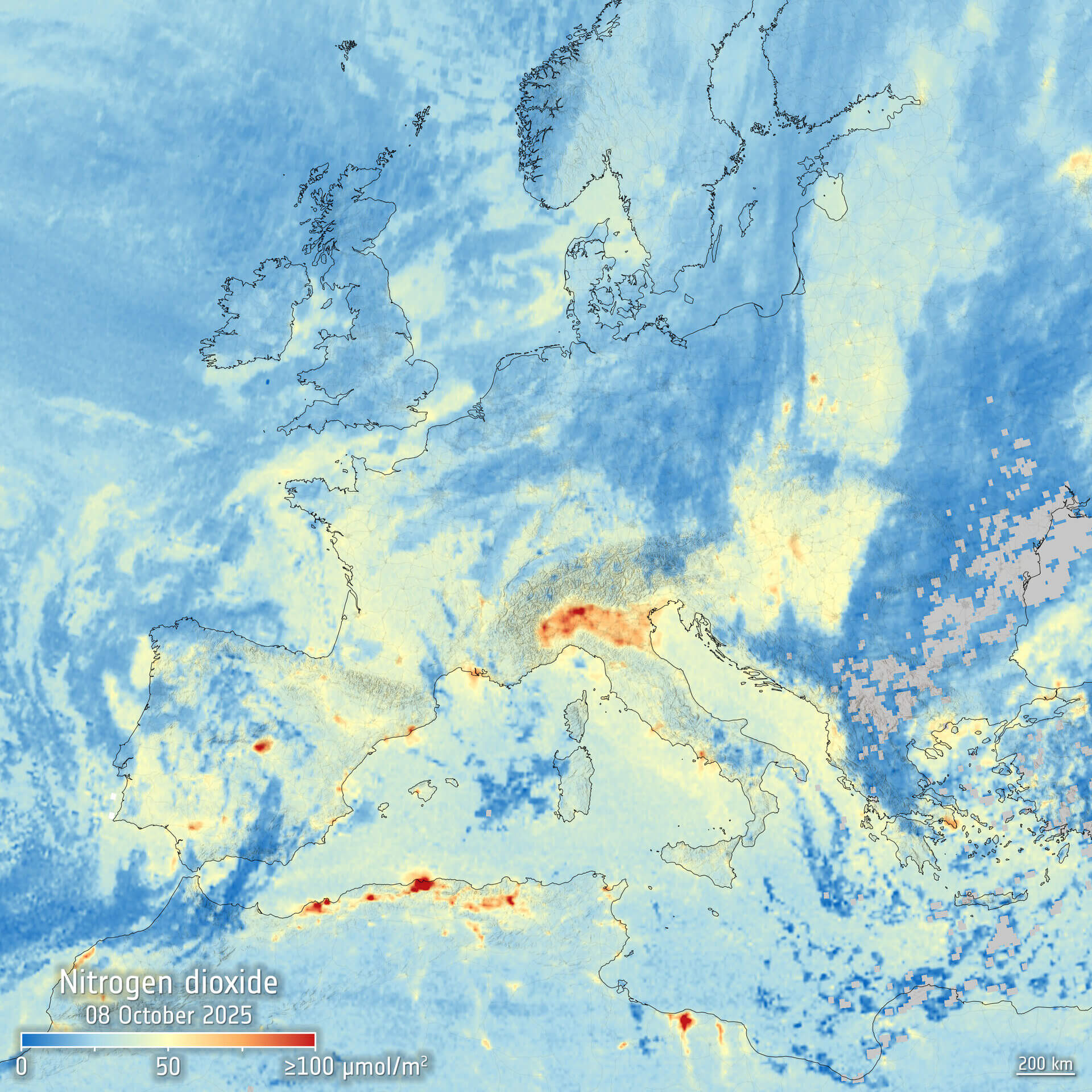
The biggest milestone so far came on 21 October 2025, when ESA released the first set of S4 images processed by the S4 L1RP. Together with ESA, our team processed the first images live – a nerve-racking but rewarding moment when the successful results appeared.
The images highlighted concentrations of atmospheric nitrogen dioxide, ozone, and sulphur dioxide, and while the instrument and software are still undergoing commissioning, they clearly indicate that the instrument is healthy and functional, marking a major milestone for both Sentinel 4 and the software.
The bigger picture
Over the past decade, the Sentinel 4 projects have taught us valuable lessons beyond the technical work. The process has never been a simple linear path from client to contractor; instead, it has relied on close collaboration together with ESA, EUMETSAT, Airbus, S&T Norway, and other partners. In long projects like this, everyone’s understanding develops over time, making flexibility, openness, and an agile mindset essential.
For me, the significance of the project lies not only in the end result — a satellite providing critical information about Earth’s atmosphere — but also in the way the work has brought together a multinational consortium. Each team has contributed its own expertise, helping us advance technically while contributing to a peaceful future for Europe.
I would like to warmly thank our team, especially Project Manager Juho Miettunen, as well as the teams from ESA, EUMETSAT, Airbus, and S&T Norway for their close collaboration. The success of this work was recognised in November 2025, when our team received ESA’s Excellence Award for best subcontractor — an acknowledgement we will remember for a long time.
Picture: Contains modified Copernicus Sentinel data (2025), processed by IUP-Bremen/DLR/ESA
How we enable critical space missions and transform complex satellite data into value?